
[
      {
        "name": "500x250 Ad",
        "insertPoint": "5",
        "component": "15667920",
        "parentWrapperClass": "",
        "requiredCountToDisplay": "1"
      }
    ]
There has been water everywhere.
A very wet spring means that bodies of water across Upstate New York are spilling over their banks. Wetlands and swamps are full. And so is Lake Ontario, which is what the other water would normally drain into.
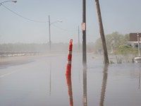
For the home and business owners on Lake Ontario's southern shore, the flooding has been a slow-moving nightmare. Water – pushed some days by high winds – has been clawing into beachfronts and lawns, shifting sand, flooding buildings, closing roads.
Docks at marinas are under water. Businesses have been closed. Homeowners have been piling up sandbags, trying to stave off the lake. And many of the lakefront landowners and the elected officials who represent them are furious, blaming the loss of property and revenue on new regulations that control the flow of water out of Lake Ontario into the St. Lawrence River.
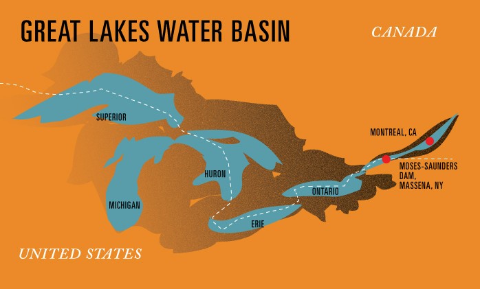
The regulations, provided in a report known as Plan 2014, were put together by the International Joint Commission, an organization created by the US and Canada to regulate the use of boundary waters – the five Great Lakes and the rivers that border the two nations – and to look into any disputes over that use.
The high water and the problems it has caused are not Plan 2014's fault. The level of Lake Ontario is probably higher than it would have been had there been no Plan 2014. But only slightly.
The lake level is high predominantly because of the rain and the snowmelt that preceded it. Nature is the biggest influence on the lake's water levels, and letting water through a dam can have only so much effect against a gargantuan lake.
Waterfront property is prime real estate. And proximity to the lake can provide major economic benefits to communities like Olcott in Niagara County, Greece and Irondequoit in Monroe County, and Sodus Point in Wayne County. Unless the water gets unusually high.
Which it has this spring.
It's no small matter when water threatens to seriously damage or destroy your house. No small matter to be unable to open your small business for days at a time because water has closed roads or flooded your building.
Shoreline property owners have been pleading for help and attacking the IJC. And politicians representing the communities along Ontario's southern shore have joined them.

In her recent State of the County address, Monroe County Executive Cheryl Dinolfo lashed out at Plan 2014. The high water and flooding, she said, "are eroding our shoreline, threatening our infrastructure, impacting our residents, and potentially damaging our tourism and recreation economy."
"Monroe County's shoreline is being ravaged," Dinolfo said, "and this is not an isolated event."
Dinolfo called on the IJC to reduce the lake level. And she said the federal government should "provide restitution for property damage and economic loss along Lake Ontario and provide resources so that this won't happen again."
In March, Western New York Congressional Representative Chris Collins, who's been fighting Plan 2014 for several years, and Syracuse-area Representative John Katko asked that Congress prevent "the use of any federal funding" to implement Plan 2014 for the remainder of this fiscal year.
In late April, Collins and Katko wrote President Trump asking him to withdraw the United States from participating in the plan's implementation and to replace current US representatives on the IJC with "individuals who will truly protect our best interest."
State Senator Joe Robach called Plan 2014 "disastrous" and said the IJC should re-examine it and "make the protection of the south shore of Lake Ontario its number one priority."
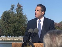
And earlier this month, Governor Andrew Cuomo – who said he had not supported Plan 2014 – announced that the state was asking the IJC to release more water through the dam "to lower Lake Ontario water levels and protect impacted communities."
A lot of people live along the Lake Ontario and St. Lawrence River coasts. About 60 percent of the Ontario and St. Lawrence shoreline has been developed for housing, according to the report, and in Monroe County that figure is nearly 90 percent. In total, all around the lake and along the St. Lawrence above the Moses-Saunders Dam, there are about 25,000 privately owned properties, the report says.
The diverse uses of the water and the extensive private property ownership means that there are competing interests in the lake and the river: the owners of shoreline homes and businesses (and the elected officials who represent them), but also commercial shipping companies, charter fishing companies, marina owners, boat owners, power companies – and the lake and river ecosystem.
The IJC was created more than 100 years ago because, as its website says, the US and Canada "recognized that each country is affected by the other's actions in lake and river systems along the border."
The IJC's members – three from the US (appointed by the president) and three from Canada – manage the use of all that water, aided by the IJC's boards, committees, and staff members in both countries.
Regulating the flow of water out of Lake Ontario into the St. Lawrence River began in 1958, when the Moses-Saunders Dam was completed. Construction of the dam, which spans the St. Lawrence between Massena, New York, and Cornwall, Ontario, was approved by the IJC, and it has provided enormous benefits.

The dam is an important source of hydropower for Ontario Province and New York State – and hydropower is clean and renewable. And as part of the St. Lawrence Seaway system, Moses-Saunders lets large commercial vessels continue from the Great Lakes eastward to the Atlantic.
When it was built, the International Joint Commission established the requirements for controlling the flow of the water through the dam, which affects the water level of both Lake Ontario and the St. Lawrence. Those requirements have to serve the interests of people living above the dam, along Lake Ontario, and those living below, along the St. Lawrence.
Under that set of requirements, contained in a document called Plan 1958 (since amended a couple of times and most recently known as 1958DD), the fluctuations in the lake level have been less severe.
Regulating the flow from the lake into the river "has provided significant economic benefits to basin interests" – particularly, says Plan 2014, for property owners along the lake. But the lack of fluctuation has seriously damaged coastal wetlands.
"These impacts were not understood when the project was approved," says the plan's summary fact sheet, "but it is now widely recognized that ecosystem needs must be considered along with other interests."
Over 16 years, the IJC conducted scientific studies, met with representatives of all of the diverse lake interests, and talked with government representatives from the Great Lakes Basin in the US and Canada.
The plan's developers knew that no one interest could be wholly satisfied. And property owners on Lake Ontario's southern shore – who will bear the brunt of the lake's shoreline damage – have been particularly adamant in their opposition. They've argued that the plan's developers underestimated the damage that the new lake levels will do. And the owners say they invested in their lakeshore homes and businesses based on levels set in the previous plan.
In creating Plan 2014, the IJC tried to balance the needs of property owners and the needs of the wetlands. The new plan, the IJC argues, "produces a large improvement in coastal ecosystems in return for a small reduction" in the benefits the old plan gave the shoreline property owners.
The IJC was convinced that the damage to the ecosystem had become too much. "The scientific evidence for the harm caused by Plan 1958DD is clear," Plan 2014's summary says, "and too strong to ignore."
The IJC adopted Plan 2014 last December, and it went into effect in January of this year. And then the spring rains came, and the level of water in Lake Ontario rose.
What's the difference between the old plan and the new one? In terms of the level of the water in the lake, not much.
Both the old plan and the new one protect development along the Lake Ontario shore. "Under natural conditions," says the report – with no dam, and no regulation at all – "average annual coastal damages on Lake Ontario would be approximately $46 million."

Under Plan 1958DD, the damage would have been about $18 million annually. And under Plan 2014, damages are projected at $20 million annually.
And, says the report, "even if Lake Ontario were regulated solely for the benefit of Lake Ontario shoreline property owners, disregarding the interests of shoreline owners on the lower river" – the residents of the city of Montreal, for instance – "navigation, and all other uses and interests, then Lake Ontario shoreline damages would be reduced by only about 5% from the levels produced by Plan 1958DD."
Recreational boaters will probably notice a difference, occasionally, under Plan 2014. The lake's water level will sometimes be lower during the summer: good for boaters on the lower St. Lawrence, less so for those on Lake Ontario.
Commercial shipping shouldn't be affected, the IJC says, except in "rare low water years, which have been experienced a couple of times in the last century." In those periods, boats would need to carry a lighter load.
Plan 2014 is expected to slightly boost the amount of energy that the hydropower plants at Moses-Saunders produces.
And the Nature Conservancy, which strongly supports Plan 2014, is predicting that the healthier wetlands themselves will have an economic benefit, through increased fishing, hunting, and other activities.
Lake Ontario and the people who live near it are part of an enormous – and critically important – system of lakes, fashioned and filled by glaciers. The water in Lake Ontario comes not only from rain and snow but also from the tributaries that empty into it.
Those tributaries include not only rivers and streams but also the other Great Lakes, which feed their water, one after the other, Superior and Michigan into Huron, then into Erie, and then, via the Niagara River, into Lake Ontario, which feeds water into the St. Lawrence River.
Which takes it northeastward to the Atlantic.
Together, the Great Lakes contain 80 percent of this country's freshwater and 20 percent of the freshwater of the world. They provide a major shipping route. Major cities have sprung up around them. Major industries have developed. And their beauty and natural resources attract people for boating, swimming, fishing. Lakes and rivers provide both enjoyment and revenue.
Drive a few miles west from Rochester along the Lake Ontario State Parkway, and on a clear day, you can see Toronto. But we are also connected by water with Cleveland, Detroit, Chicago, and Duluth, to Toronto, Hamilton, Sault Ste. Marie, and Thunder Bay to the west. We're connected to the farmlands and cities and villages along the tributaries that feed into their lakes.
What happens in lakes and tributaries farther west on the Great Lakes chain can affect us. And importantly, what happens in Lake Ontario can affect what happens in the St. Lawrence River and to the people, wildlife, and land alongside it – in the US and in Prescott, Montreal, Trois-Rivieres, and Quebec in Canada.
And in this record-setting spring, Lake Ontario's southern shore isn't the only area in the United States coping with high water. In early April, the National Weather Service issued a flood warning for Susquehanna County in Pennsylvania. The May 4 Detroit Free Press reported that a flood watch had been issued "for most of southeast Michigan" and warned that residents in some areas might be facing "slightly more than 3 inches" of rainfall.
Westchester County, Albany, Colorado, Arkansas, Missouri: flooding has occurred in all of those areas this spring. In Rochester, Genesee Brewing's news-generating event – floating beer fermentation tanks up the Erie Canal from Albany to Rochester – had to be delayed because the water level in the canal was too high. The high water in Lake Ontario, and the IJC's Plan 2014, had nothing to do with it. The Erie Canal connects to Lake Erie. But not to Lake Ontario.
Also struggling with the result of this spring's heavy rainfall: the residents of the province of Quebec. Flooding there in mid-May forced the evacuation of more than 3,000 people, the Montreal Gazette reported. Numerous roads and bridges closed for days. Nearly 4,500 homes were damaged.
Residents and businesses along Lake Ontario's southern shore – including many in the Rochester area – have had to cope with the effects of water well above normal this month. But so have those along the St. Lawrence. On May 17, for instance, Ontario's level was 33.1 inches above its long-term average for this time of year, according to the IJC. On the same day, though, the level of water in Montreal Harbour was 55.5 inches above average, the IJC said.
The Canadian news site Global News reported that Montreal had received almost as much rain in the first eight days of May as it normally gets in the full month. Canadian climate expert Jeannine St-Jacques told Global News that this may become far more common: "In a lot of places worldwide, we're exceeding our 100-year floods, our 1000-year floods, our 2000-year floods," said St-Jacques. "As things become more extreme, we will be seeing more."
In the end, things will settle down. The high-water season will pass, and when the spring's threat of flooding and erosion is over, shoreline owners' pleas may lead to a few tweaks in the IJC's management of the water level. State and federal officials may provide some money to help shoreline property owners repair this year's damage and better protect themselves in the future. Maybe some property owners will conclude that their homes or businesses are simply not built in a good location, and they'll move.
Regardless, one thing is pretty certain: This won't be the last test for Plan 2014 and for property owners along Ontario's southern shore. Whether this particular spring's heavy rains are due to climate change is impossible to say, but climate change is real. And its effects will include more frequent, stronger weather conditions.
Odds are, the long-range forecast for the boundary water we live along is for more rain and more intense storms, more frequently, than we've experienced in the past. And that likely will mean more water in the Great Lakes. More water in Superior, Michigan, Huron, and Erie, which will send more water into Lake Ontario and on through the St. Lawrence into the Atlantic.
And unless we plan to flood Montreal to protect property owners on the southern shore of Lake Ontario, that means more occasions when the lake will head onto the land, to flood homes and businesses and wash over streets in Olcott, Greece, Irondequoit, Sodus Point.
We can regulate the lake level, to an extent. But we can't regulate the rainfall or the severity of the storms. In the end, the water will win.

Plan 2014’s balancing act: muskrats, pike, and people
The report known as Plan 2014 places a lot of emphasis on Lake Ontario's coastal wetlands, and for good reason. Over the past 50 years, the marshes have taken the brunt of efforts to manage the lake's water levels.
The wetlands developed over centuries, through constant shifts in the lake's water levels. But in the late 1950's, US and Canadian public power utilities built a large hydroelectric dam between Lake Ontario's eastern outlet and the St. Lawrence River. And with that project came a joint US-Canadian plan for managing levels of the lake and river. For decades, international regulators have followed that plan's guidelines, which have kept water in both bodies artificially stable. The lake's waters, for example, rose and fell, but not as much as they should have.
"The highs have happened under Plan 1958DD. The lows have not happened," says Doug Wilcox, a SUNY Brockport professor who's spent much of his scientific career studying Lake Ontario's wetlands and shores.
The result in Lake Ontario: cattails have taken over vital coastal wetlands, leaving important species such as muskrat and northern pike without critical habitat.
This is the problem that Plan 2014 is supposed to alleviate, to the extent it can. The plan just took effect in January, and over the coming years it's supposed to better mimic the natural rise and fall of Lake Ontario and the St. Lawrence River.
So what does that mean? Nature, in the form of precipitation and snowmelt, has and will always be the biggest influence on the Lake Ontario and St. Lawrence River levels. But the way water flows are managed at the hydroelectric dam can have a meaningful effect, too. That's all done through complex criteria involving, among other things, high and low trigger levels. In either case, the plan is meant to moderate extremes.
The plan is also set up to better incorporate climate change, past and future, into the IJC's decision-making. The Great Lakes are already experiencing heavier, more intense snow and rain storms, as well as a greater number of hot, precipitation-free days. The shifts that have already happened had rendered obsolete the forecasts in Plan 1958DD.
Under Plan 2014, when the lake's water should be naturally high, such as during the spring snowmelt or when the areas that drain into the lake have a wet year, the levels will be allowed to rise accordingly. When the waters are supposed to be low, such as during late summer or during dry spells, they'll be allowed to drop further than under Plan 1958DD.
The plants that should be growing in Lake Ontario's wetlands, particularly sedges and grasses common in healthy marsh meadows, need that variability. And as the waters rise and fall over a period of years, various wetland plants should make a comeback, Wilcox says. The cattails may even die off over time as drier, lower-water periods happen, he says.
The shift should improve habitats for native species. The northern pike, a prized gamefish and a predator fish with an important place in wetland food webs, for example, prefers to spawn in grassy meadow marshes. And where those marshes remain relatively intact, cattail mats often block pike from them, Wilcox says.
"This can be viewed as the second largest wetland restoration project in the country, in the continent, after the Everglades," says David Klein, senior field representative for the Nature Conservancy of Central and Western New York. "The impact on the entire coast of Lake Ontario and the shore of the St. Lawrence are projected to be considerable. That's good for all of us."
Healthier, diverse wetlands should also better perform other natural functions, including some that directly benefit humans. Research has shown that wetlands, especially healthy ones that aren't overcrowded, filter nutrient pollutants – animal waste or all manner of fertilizers, for example – out of the water, Klein says. Those pollutants encourage algae and bacteria growth in the waters near the Lake Ontario shore. Research indicates that healthier, more diverse wetlands could help reduce that problematic pollution, Klein says.
Cattail mats are less effective as pollution filters, Klein says.
Some shoreline property owners have complained – sometimes sarcastically – that Plan 2014 places wetlands and muskrats over homeowners, some of whom have built their houses right up to the water. But long term, the same fluctuations that are expected to help wetlands rebound, could also help coastlines rebuild.
When levels are held high, the water eats at beaches, dunes, and bluffs – particularly when the wind picks up and drives the waves – without replenishing them. But when water levels fluctuate following natural patterns, the high and low water rhythms knock the sediment loose and carry it further down shore, replenishing and building up stores. That is, if property owners haven't reinforced the shores, preventing the water from scouring off sand and sediment.
"These are the same low lake levels that the homeowners need," Wilcox says. "The homeowners should be glad that 2014 is in place."
Related Stories

Speaking of...
-

As Lake Ontario rises, IJC looks to deviate from Plan 2014
Apr 6, 2020 -
New York to sue IJC over lake levels
Oct 10, 2019 -
Federal watchdog agency to review Plan 2014
Aug 9, 2019 - More »
Latest in News
-

Meet CITY's new arts writer: Patrick Hosken
Apr 1, 2024 -

Rochester misses the boat on fast-growing Great Lakes cruises
May 8, 2023 -

Monroe County seed libraries take root
Apr 21, 2023 - More »
More by Jeremy Moule
-

ROCHESTER TEN
ANNETTE RAMOSAug 1, 2023 - More »
More by Mary Anna Towler
-

Police reform: advocates on what should come next
Oct 22, 2019 -

Court clears the way for Police Accountability referendum
Oct 17, 2019 -

Dade outlines initial actions on district deficit
Oct 9, 2019 - More »

Finger Lakes Science & Technology Showcase @ Memorial Art Gallery
Please join the University of Rochester's Center for Emerging & Innovative Sciences...

Classic Book Discussion discusses A Doll's House by Henrik Ibsen @ Irondequoit Library
Join us for a discussion A Doll’s House by Henrik Ibsen.Book copies...